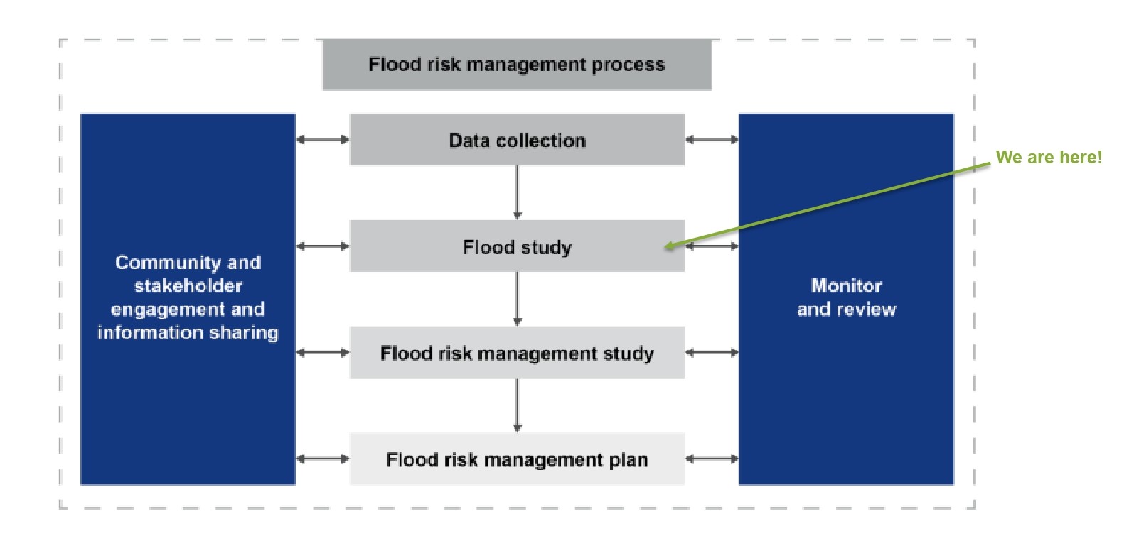
This study expands our existing flood knowledge and updates current mapping using industry best practice. It essentially maps future flood-prone areas and is the first step in better understanding and mitigating flood risks, which is critical to improving local planning, emergency management and development guidelines.
To help understand the study, we've provided an interactive map, information video, FAQs, definitions and locality maps. Hard copies of the study are also available to browse at Council's Laurieton Customer Service Centre and Kendall Community Centre.
The Camden Haven River and Lakes System Flood Study is a technical investigation into the way floods behave within the catchment, based on analysis of detailed historical data and computer models to simulate a range of flood events.
This flood study extension was triggered by significant flooding in March 2021, which highlighted that although flooding of the lower reaches of the Camden Haven River below Kendall and Kew was well understood, there was a lack of reliable flood data for smaller communities along the banks of the upstream tributaries.
New data has been used to develop a model to simulate flooding in the upper reaches of the catchment above the areas covered by the 2013 Camden Haven River Flood Study.
As well as identifying and defining existing, future and potential future flood issues, the study will guide planning for future development and ensure that Council meets its obligation to manage land under the NSW Government Flood Prone Land Policy.
- To better understand and mitigate flood risks - leading to improved local planning, emergency management and development guidelines
- To define flood characteristics in areas of the floodplains upstream of modelling for the 2013 Flood Study
- To take advantage of the extensive data gathered during and since the March 2021 event, so flood models can be validated and used to more reliably predict flood characteristics
- To provide flood mapping for a range of design storm events and projected climate change scenarios
- To prepare a prediction for the Probable Maximum Flood (PMF) across the catchment to inform emergency planning
While the whole catchment comprises approximately 650km2, this flood study extension includes modelling upstream of Kew and Kendall, along the Camden Haven River and tributaries.
The main components include the Camden Haven River west of Kendall and major tributaries of the Camden Haven River such as Black, Upsalls and McLeod Creek. It excludes North Brother Mountain.
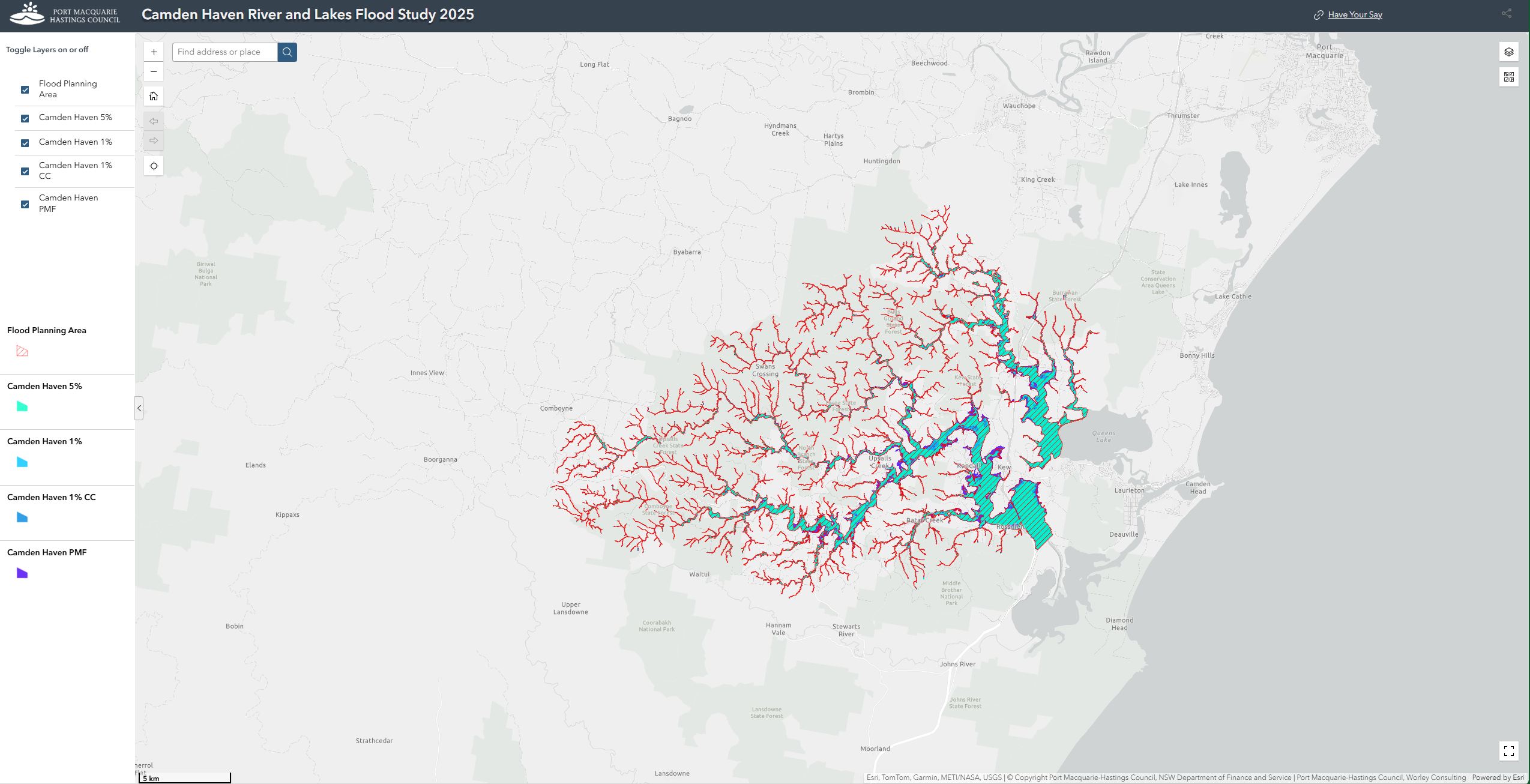
To understand the locality maps below, please consider reading the Executive Summary in the flood study first, as it sets out key terms and definitions.
Please note that the maps show flood models for different flood events in your area, so it is important to review the captions and legends on each map individually.
Locality maps:
Have Your Say
To help the community understand the flood study, ask questions and provide feedback, you are invited to register for an information session at Kendall Services & Citizens Club from 6pm to 7.30pm on 17 November 2025. If you would like to attend, please register below.
You can download the full flood study, view the information video and read FAQs to the right, or below if you are viewing this page on a mobile device.
You can provide feedback by:
- Making a submission by completing the short survey below
- Emailing your feedback to: council@pmhc.nsw.gov.au
- Writing to:
The General Manager
Port Macquarie-Hastings Council
PO Box 84
Port Macquarie NSW 2444
Submissions close at 5pm on 2 December 2025.
Next steps
Once public submissions close on 2 December 2025 the flood study will be presented to Council for endorsement. Pending Council approval, the updated flood mapping will be accessible via the SES Flood Portal and PMHC website’s online mapping portal: Flood Certificates and Flood Enquiries Port Macquarie Hastings Council.
We are committed to ensuring that the Camden Haven River and Lakes System Flood Study is comprehensive and reflective of community insights. Public feedback is a crucial component of this process and will be utilised to:
- Validate modelling: Feedback will be reviewed to confirm and validate the flood modelling undertaken. This ensures that the data and assumptions used are accurate and representative of real-world conditions
- Inform future planning: Feedback will directly inform planning for the next stage of works. This includes the commencement of an update to the Camden River Floodplain Risk Management Study and Plan, set to begin in the 2025/26 financial year.


