Submissions have now closed. Thank you for your interest.
Submissions are now closed. If you would like to stay informed on updates, click on the 'Subscribe' button.
Update
At the July 2025 Ordinary Council Meeting, Council resolved to defer the adoption of the Hastings River Flood Study Extension Report. This decision allows for further review of planning implications, community concerns and technical aspects raised during and after the public exhibition process.
What happens next? Council will receive a further report that includes: a summary of community submissions; any resulting changes made to the study and; updates on additional community engagement.
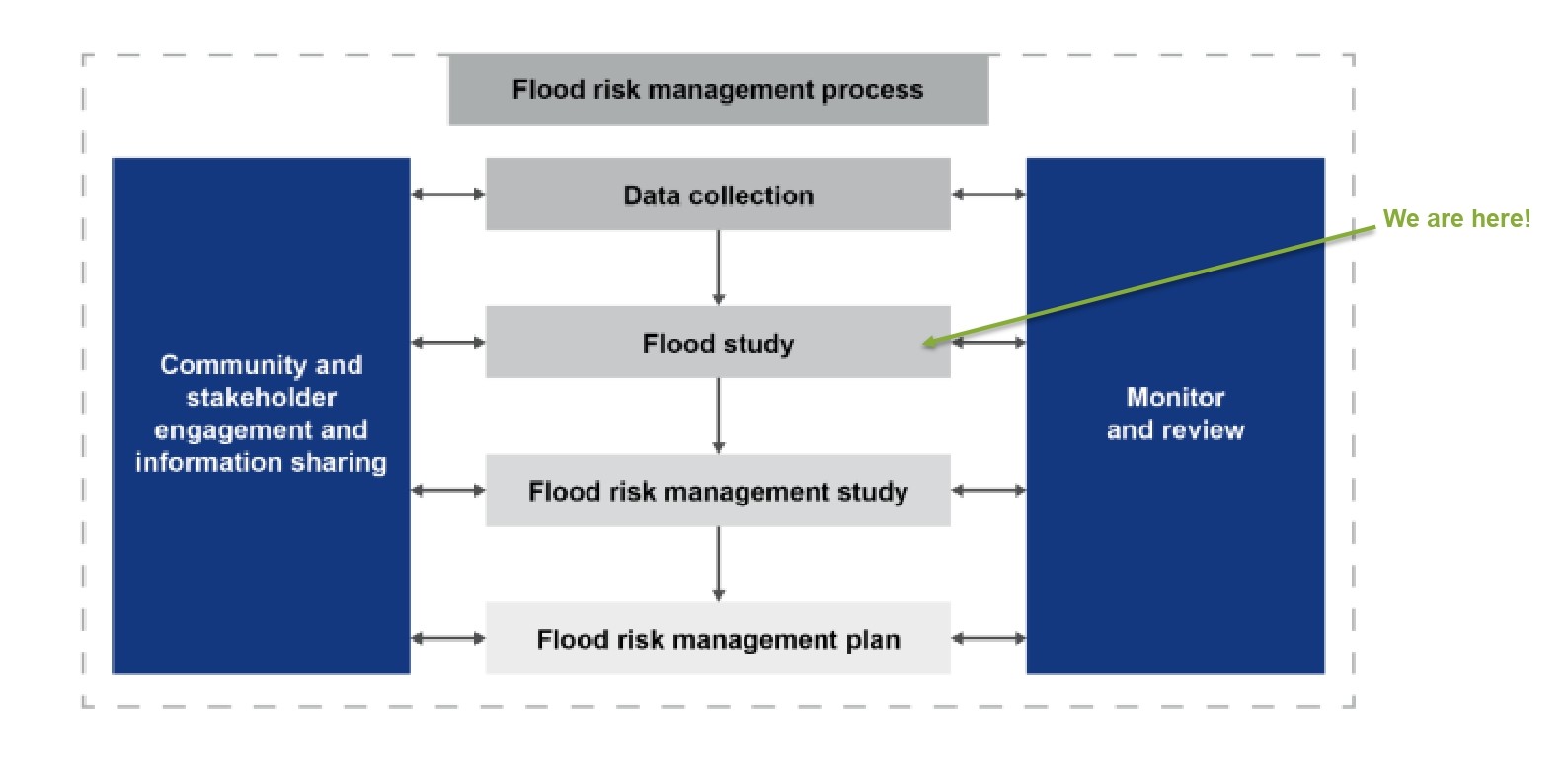
The Hastings River Flood Extension Study is a technical investigation into the way floods behave within the Hastings River catchment, based on analysis of detailed historical data and computer models to simulate a range of design flood events.
An update to the Hasting River Flood Study was triggered by significant flooding in March 2021. At that time, no flood information was available for the western/upper reaches of the catchment, beyond Beechwood and Telegraph Point.
The study identifies flood depths, velocities and extents, which are used to create a technical report that Council can use to better understand and manage the risks associated with flooding to the region.
The aim is to expand our existing flood knowledge and update current mapping using industry best practice so that we have the appropriate information when responding to queries, developing flood controls and assisting with emergency preparedness and response.
As well as identifying and defining existing, future and potential future flood issues, the study will guide planning for future development and ensure that Council meets its obligation to manage land under the NSW Government Flood Prone Land Policy.
Study objectives
- Extend flood mapping to additional areas upstream of the 2006 Hastings River Flood Study and subsequent updates
- Develop and calibrate a hydrologic model for the Hastings River catchment to align with recently updated standards, and to include the latest available rainfall data
- Enhance existing flood models along the Hastings, Wilson and Maria Rivers using with the inclusion of major tributaries
- Provide flood mapping for a range of design storm events and projected climate change scenarios to define the floodplain, depth and velocity of water for a range of flood events
- Prepare a prediction for the Probable Maximum Flood (PMF) across the catchment to inform emergency planning and to replace the previously determined ‘extreme’ flood
Areas covered
The Hastings River catchment covers an approximate area of 3,700 square kilometres, draining from the Great Dividing Range approximately 120km from the coast to the Tasman Sea at Port Macquarie. Major tributaries include the Hastings River, Forbes River, Ellenborough River, Pappinbarra River, Morton's Creek, Maria River and Wilsons River.
The catchment has a history of flooding, with extensive damage caused to private and public property in proximity to the Hastings River and major tributaries in 1963, 1968, 1978, 1995 and more recently in 2013 and 2021.
While the full flood study and an Executive Summary are available to view or download under Documents to the right, we have extracted sections that are relevant, or applicable, to particular areas. To understand these maps, please consider reading the Executive Summary first, as it sets out some key terms and definitions. Please note that the maps show flood models for different flood events in your area, so it is important to review the captions and legends on each map individually.
Maps relevant to townships/localities:
- Beechwood, Redbank, Wauchope, King Creek, and Sancrox
- Ellenborough, Long Flat, Bagnoo
- Hartys Plains, Brombin, Huntingdon, Koree Island
- Maria River, The Hatch, Telegraph Point
- Morton's Creek, Frazers Creek and Bellangry
- Pappinbarra River
- Port Macquarie, Fernbank Creek, North Shore, Riverside
- Rawdon Island, Sancrox, Blackman's Point and Fernbank Creek
- Wilson River, Rollands Plains, Bellangary
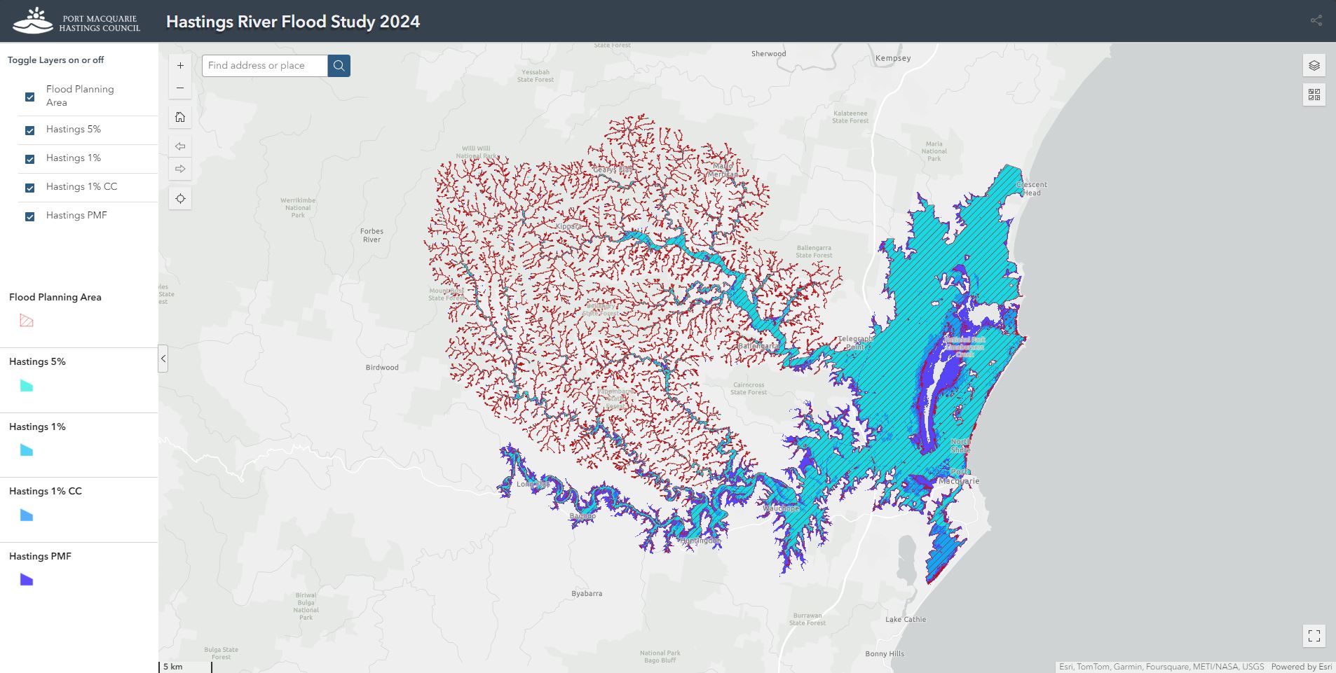
Click to view our interactive map
Have Your Say
To help the community understand the Flood Study, ask questions and give feedback, residents are invited to register for one of the following information sessions:
- Monday 31 March 2025: 6 - 7.30pm at Port Macquarie-Hastings Council Function Room
- Wauchope - 8 April 2025: 6 -7.30pm at Wauchope Community Arts Hall
- Telegraph Point - 15 April 2025: 6 - 7.30pm at Telegraph Point Community Hall
These sessions will include some presentations as well as hardcopy versions of the relevant information, with formal and informal Question and Answer sessions with subject matter experts.
You can download and view the full flood study, Executive Summary and FAQ's to the right under the documents tab, or below if you are viewing this page on a mobile device.
Provide your feedback by making a submission:
- Complete our submission survey below; or
- Email your feedback to council@pmhc.nsw.gov.au; or
- Post your feedback to:
Chief Executive Officer
Port Macquarie-Hastings Council
PO Box 84
Port Macquarie NSW 2444
Consultation closes at 5pm on 28 April 2025.
Next steps
Once public submissions close on 28 April 2025 the flood study will be presented to Council for endorsement. Pending Council approval, the updated flood mapping will be accessible via the SES Flood Portal and PMHC website’s online mapping portal: Flood Certificates and Flood Enquiries Port Macquarie Hastings Council.
We are committed to ensuring that the Hastings River Flood Study is comprehensive and reflective of community insights. Public feedback is a crucial component of this process and will be utilised to:
- Validate modelling: Feedback will be reviewed to confirm and validate the flood modelling undertaken. This ensures that the data and assumptions used are accurate and representative of real-world conditions
- Inform future planning: Feedback will directly inform planning for the next stage of works. This includes the commencement of an update to the Hastings River Floodplain Risk Management Study and Plan, set to begin in the 2025/26 financial year
- Community Engagement Report: A summary of the feedback and how it has been considered will be published. This report will highlight key themes and concerns raised by the community and outline actions taken in response.
Submission
CLOSED: This survey has concluded.
Submission
Submissions close 5pm on 28 April 2025.
Writing a submission is one way of sharing your views and opinions with Council. All submissions are considered before making a decision and your submission may be included in a report to Council.
Note: Information collected via submissions and petitions is public information, this information may form part of Council reports or made public in their entirety subject to the provisions of the Local Government Act 1993 or the Government Information (Public Access) Act 2009 (GIPA Act). You may request, in writing, that Council suppress the personal information in your submission from public release, if you consider that the personal safety of any person would be affected if the information was not suppressed Any such request will be dealt with in accordance with the GIPA Act and the Privacy and Personal Information Protection Act 1998.
Information session registration
CLOSED: This survey has concluded.


